So this is it! My first born son has accepted to the Lord's call to serve the people in the Marshall Islands Majuro Mission. He is currently on the island of Tarawa and will serve on the eastern islands in the Kiribati Region not the Marshall Islands which are located west of the Kiribati. Kiribati is pronounced like Kee-de-bus. I will attempt to keep this blog fun and hopefully inspiring and rewarding for all those who read it. Good luck to me!
First FUN Facts:
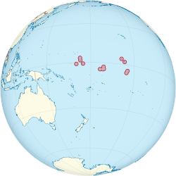
The Republic of Kiribati
Motto: "Te Mauri, Te Raoi ao Te Tabomoa"
"Health, Peace and Prosperity"
Anthem: Teirake Kaini Kiribati
Stand up, Kiribati
Capital and largest city: Tarawa 1 degree 28 North 173 degree 2 East
Official Languages: English. Gibertese
Area: total 313 square miles
Population estimated in 2010 - 103,500
GDP nominal per capita $1,592
Currency- Kiribati dollar and Australian dollar
Time Zone- UTC +12, +13,+14
Drives on the left side
The Republic of Kiribati is an island nation in the central Pacific Ocean. The nation comprises 33 atolls and reef islands and one raised coral island, Banaba. They have a total land area of 310 square miles and are dispersed over 1,351,000 square miles. Their spread straddles the equator and the International Date Line, although the Date Line is indented to bring the Line Islands in the same day as the Kiribati Islands. The permanent population is just over 100,000, half of whom live on Tarawa Atoll. South Tarawa consists of a number of islets, connected by a series of causeways. These causeways comprise about the half the area of Tarawa Atoll. An atoll is a ring-shaped coral reef including a coral rim that encircles a lagoon partially or completely. The coral of the atoll often sits atop the rim of an extinct seamount or volcano which has eroded or subsided partially beneath the water. The lagoon forms over the volcanic crater while the higher rim remains above water or at shallow depths that permit the coral to grow and form the reefs. For the atoll to persist, continued erosion or subsidence must be at a rate slow enough to permit reef growth upwards and outwards to replace the lost height.
In 1999, two uninhabited islands disappeared underwater. The United Nations predicts that sea levels will rise 20 inches by 2100 due to global warming which will cover more of these atolls. Kiribati has a low risk or cyclones and does experience flooding and destruction of seawalls and coastal infrastructure.
The weather is pretty constant everyday - 88 degrees everyday with a low of 76 at night. Humid and wet!
Kiribati is one of the world's poorest countries. In one form or another, Kiribati gets a large portion of its income from abroad. Examples include fishing licenses, development assistance, and tourism.
.


 |
| Please excuse the jump out of the pool and read the mail hair! I think our excitement before and after the reading was the same! |